
Winter Solstice Field Trip and Hooley
Date/Time
Sunday, December 21, 2014
11:00 am - 3:00 pm
Location
Ferry Hill
Categories No Categories
“There are mushrooms for a brain,
owl talons, vervain, and mandrake
and something else, unnamed,
that sets the shallow winter sap upon its face
and grants the Greenman motion
and binds him to the forest waste.”
– Ari Berk, Anatomies
Field trip co-sponsored by the Maryland Native Plant Society, Potowmack Chapter of the Virginia Native Plant Society, and Botanical Society of Washington
Leaders: Rod Simmons and Carole Bergmann
Celebrate the beginning of the winter season at Ferry Hill with its spectacular scenery and diversity of native plants, wildlife, and natural communities!
From Kathy Bilton of the Botanical Society of Washington: If anyone is interested in carpooling to the Ferry Hill trip – or has room to provide a ride – please email Kathy at kathy@fred.net closer to the time and she will send out a list of names, general location, and contact info which she has received to the list so that folks wishing transportation to the field trip can arrange something. A number of folks in the Alexandria and Arlington area are currently looking for a ride to the site.
Ferry Hill, part of the C&O Canal National and Historical Park, sits atop a high bluff and cliffs overlooking the Potomac River just opposite Shepherdstown, West Virginia. Terrace deposits of large quartzite cobbles and boulders of the Pleistocene and Tertiary cap the upper elevations and overlie the much older (Lower Ordovician to Middle Cambrian) limestone, marble, dolomite, and dolostone of the Conococheague Limestone, Big Spring Station Member, and Elbrook Limestone that form the bedrock and exposed cliffs.
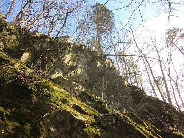
Near-vertical, north-facing limestone cliffs with American Arborvitae (Thuja occidentalis) overhanging the Potomac River at Ferry Hill. Click here for more iinformation on these natural communities. Photo by R.H. Simmons.
From the summit of the site, we will the traverse the exceptional, old-age Rich Cove and Slope Forest that extends along the north of the property overlooking the C&O Canal and Potomac River. After descending from the forest, we will walk along the base of the cliffs and the towpath to see a diversity of evergreen ferns, bryophytes, and other plants.
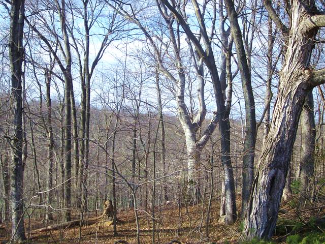
Ancient Cucumber-tree (Magnolia acuminata) in pristine Appalachian Rich Cove Forest at Ferry Hill – the perfect location for this year’s nemeton! See here and USNVC: CEGL007710 for more information on these natural communities. Photo by R.H. Simmons.
During this year’s trip, we’ll see a diversity of species and natural communities, including old-age Sugar Maple (Acer saccharum), Cucumber-tree (Magnolia acuminata), White Oak (Quercus alba), Northern Red Oak (Quercus rubra), Chinquapin Oak (Quercus muehlenbergii), Tulip Tree (Liriodendron tulipifera), White Ash (Fraxinus americana), American Beech (Fagus grandifolia), and American Basswood (Tilia americana var. americana), as well as American Arbovitae (Thuja occidentalis), Black Maple (Acer nigrum), Slippery Elm (Ulmus rubra), Paw Paw (Asimina triloba), and others. We’ll also see many species of evergreen ferns and other plants growing on the limestone cliffs.
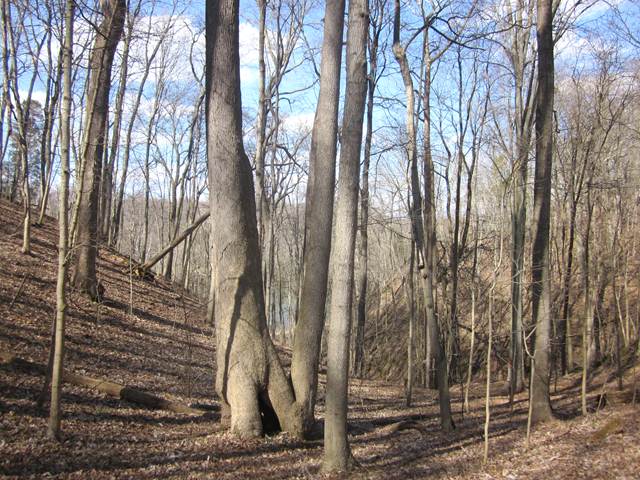
Rich Slope Forest at Ferry Hill with old-age Sugar Maple (Acer saccharum), right foreground, American Beech (Fagus grandifolia), back near center, White Ash (Fraxinus americana), and others. Photo by R.H. Simmons.
If there’s time, we also hope to measure for nomination to the Maryland Big Tree Register two champion-sized Cucumber-trees, and possibly other exceptionally large and old trees.
Field trip is free and open to non-members. Registration is not required.
For ARMN members, this event will apply towards advanced training hours in botany, dendrology, forest ecology, and geology.
Wear sturdy shoes and bring lunch or snacks and water. Most of the walk traverses rolling, fairly open forest along trails, though some steep grades will occasionally be encountered.
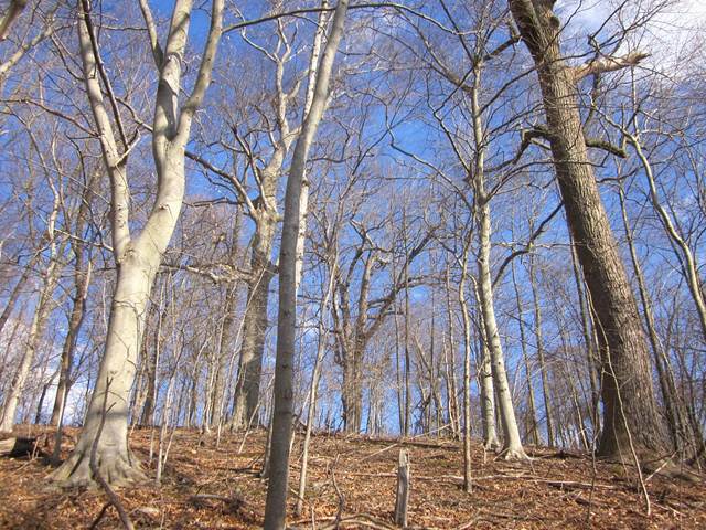
Rich Slope Forest at Ferry Hill overlying limestone bedrock with large, rounded sandstone and quartzite cobbles deposited by the ancestral Potomac River scattered over the surface. Photo by R.H. Simmons.
Directions: In Maryland from the Capital Beltway (495), take 270 west towards Frederick. At Frederick, take I-70 west a short ways to Alt. 40 west (Exit 49). Take Alt. 40 west to Boonsboro. Turn left onto Shepherdstown Pike (Rt. 34) in Boonsboro and proceed to entrance on right at Ferry Hill just before bridge over Potomac River. Proceed up driveway to parking area beyond mansion.
From Virginia, take Rt. 9 west to Hillsboro. Just past Hillsboro, turn right onto Rt. 671 and proceed to Loudoun Heights at Rt. 340. Turn left onto Rt. 340 and proceed a short ways past Harpers Ferry and Bolivar to right turn onto Rt. 230 (Shepherdstown Grade Road). Proceed north on Rt. 230 to Shepherdstown and to junction of Rt. 45. Turn right onto Rt. 45 and proceed a short ways, crossing the Potomac River bridge, and turning left almost immediately on the Maryland side into the entrance drive to Ferry Hill. Proceed up driveway to parking area beyond mansion. (Rt. 45 is a West Virginia route which becomes Rt. 34 in Maryland.)
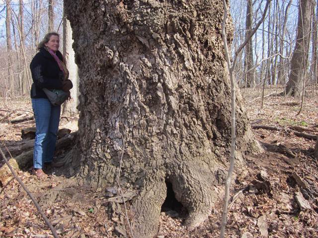
Ancient Tulip Tree (Liriodendron tulipfera) at Ferry Hill. Many old-age forest trees, especially Tulip Tree, become hollow with age, but are perfectly healthy and generally not prone to being blown down. Photo by R.H. Simmons.
In the event of heavy-steady snow, sleet, or pouring rain, or icy, dangerous conditions of roads, the field trip will be cancelled. The rain or snow date will be TBA in January 2015. In the event of a rain date for the walk, the description and route will follow as planned, with the emphasis on winter evergreens.
Contact: Liz Jones at elksjones@aol.com or http://mdflora.org/events.html
For more on the geology of the park, below is a link to the excellent USGS paper (Southworth et al.): Geology of the Chesapeake and Ohio Canal… The pages with geologic maps and explanations for the Ferry Hill site are 124 and 125. The park is roughly between mile markers 72 and 74, slightly northeast from top to bottom and just above Shepherdstown Pike (Rt. 34) on the map on page 125.